CHLO4MSFD Service has been used to provide Chlorophyll-a data across all regional seas and beyond, as material for the article “Yes, We Can! Large-Scale Integrative Assessment of European Regional Seas, Using Open Access Databases” published in “Frontiers in marine science”.
This study aims to demonstrate that assessing the status of large marine areas, under the Marine Strategy Framework Directive (MSFD), is now possible by using available tools (i.e. the Nested Environmental status Assessment Tool -NEAT-), available indicators and thresholds, and available open source data.
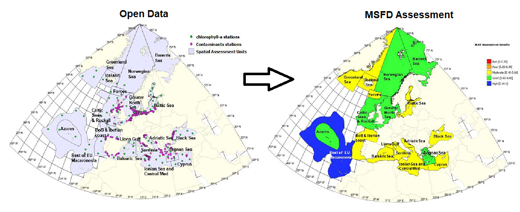
In particular, CHLO4MSFD has been used to extract chlorophyll-a data to support assessment of eutrophication, as one of the 11 descriptors (D5) of the MSFD.
“For eutrophication (D5), one of the indicators used across all Member States (e.g., within the Water Framework Directive), is 90th percentile of chlorophyll a, calculated using a period of 5 years (European Commission, 2018). In order to calculate such indicator, we used a web tool3 to extract chlorophyll-a data from 87 different locations distributed through the different subregions and subdivisions considered (Figure 1). These chlorophyll-a data are extracted from different Copernicus marine products depending on the regional sea considered (Table 1). In the case of Barents Sea, the web tool does not provide data for calculation, and in the Norwegian Sea only for the southern part. Then, the 90th percentile of chlorophyll a was calculated, using the period between 2009 and 2014, for each location. Finally, the mean and standard error values of the 90th percentile of chlorophyll-a were calculated for each SAU”
You can access this publication Here